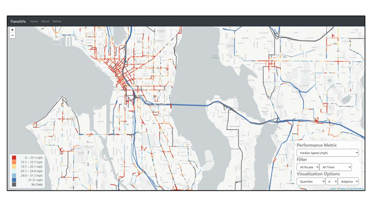
TransitVis Corridor Performance Evaluation Tool
Issue
People who take the bus depend on reliable service to reach their destinations on time. This in turn helps to grow ridership. To keep schedules current and account for typical surface street delays, transit agencies often make broad adjustments along the entire route without identifying where the true problem areas may exist that could be addressed.
Spark
What if we could use evolving bus data technology to pinpoint trouble spots across an entire network, especially in areas that are impacting multiple routes?
Transit agencies collect and distribute bus route data openly to allow web and app-based developers to widely share schedules across different digital platforms. The standard format is known as the “General Transit Feed Specification,” or GTFS. The insights are limited as actual service may not reflect scheduled service identified through the GTFS feed.
The next iteration of this is called GTFS-RT and gathers real-time data from automatic vehicle locators (AVL) on buses that capture actual travel speeds and locations with more precision. This can help identify problem areas along a given route to aid in spot improvements. The development of a tool that captures and visualizes this data can serve as a roadmap for other agencies to follow.
Overview
Next-generation open-source bus data is used to visualize transit network performance at the level of individual street segments, and to identify chronic slow spots for further evaluation by transit agencies and city partners to improve reliability. The project sought to develop a method that could be used universally and help inform trip scheduling and identify surface street hot spots where modifications may be considered.
When launched in 2020, the project initially intended to use the data to identify locations where delivery and ride hailing services may potentially affect bus trips and increase travel times between stops. These insights would help inform city transportation agencies of areas in need of curbside management. Adjustments could then be made to improve bus reliability and also allow personal pick-up and drop-offs to function harmoniously. Due to the pandemic, ride hailing dropped significantly, and early assessments indicated that curbside pick-ups and drop offs were not an issue to bus service on the studied routes. Still, the project team found a use in the real-time data that has a wider application for other transit agencies and city street managers.
Innovation
The project team developed a tool that transit agencies can use for more precise identification of problem areas at the street level that can result in unreliable bus trips, rather than making schedule adjustments along the entire route. They did this by using an open-source real-time data feed known as “General Transit Feed Specification – Realtime,” or GTFS-RT, that fed active bus coordinates and schedule stop information at 10-second intervals. Since September 2020, this data from the entire King County Metro network has been scraped continually and stored to an Amazon Web Services (AWS) server and updated daily on TransitVis, the project website. As a result, a framework for using GTFS-RT data for locating and characterizing service performance metrics is now available for others to use.
This web based visualization tool can be viewed here. It is being updated daily with aggregated performance metrics from our database.
Materials
The study is peer-reviewed and completed – read the report.
Impact
- This work will help identify network-wide road and route segments with slow and/or unreliable bus travel times.
- We expect that this work will generate reusable analytical tools that can be applied by local agencies on an ongoing basis and by other researchers and transportation agencies in their own jurisdictions.
The outcomes of this work will enable identifying corridors with slow and/or unreliable bus travel times as candidates for specific countermeasures to increase transit performance, such as increased enforcement, modified curb use rules, or preferential bus or street use treatments. Targeting such countermeasures towards priority locations will result in faster and more reliable bus operations and a more efficient transportation network at a lower cost to transit agencies.
Team
This study was sponsored by Amazon, Bellevue Transportation Department, Challenge Seattle, King County Metro, Seattle Department of Transportation, Sound Transit, and Uber, with support from the Mobility Innovation Center at UW CoMotion.
About the Sustainable Transportation Lab: We study how to make our transportation system more economically viable and environmentally benign and to ensure that it provides access to opportunities for all. We focus on how emerging transportation technologies, human behavior, and public policy interact to shape key sustainability outcomes. To develop and prescribe solutions that work in the real world, we start from a clear-eyed, empirically grounded perspective based on experimentation, evidence, and rigorous analysis.
Academic Department
Faculty Leadership
Contributors
- Zack Aemmer
- Borna Arabkhedri
- Don MacKenzie (Principal Investigator)
- Andisheh Ranjbari (Co-Investigator)


